

Crop scouting begins after sowing when crops start to sprout and last throughout the growing season. This activity is critical because it helps to detect current and potential problems of plants. The results of this procedure make growers more informed, so that they can make more effective decisions at all growth stages. In addition, even if you cannot fix the problem, the crop scouting will help determine the reasons for different issues and avoid them in the future.
Crop Scouting Basics
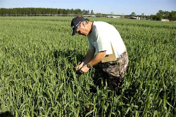
It is crucial to understand and recognize the different stages of growth and how the plants should look in the process. To fix problems in time, you need to be able to distinguish between normal and abnormal plants. To see how you can get essential information and understand whether everything is on schedule or whether your crops are significantly affected by the environment, visit here.
You can understand that something is wrong with the plant by the plant’s color; in the shape of the leaves, they can wrinkle, and unhealthy plants are characterized by loss of leaf tissue and wilting. In addition, it is worth paying attention to the roots, since sick plants can have deformed roots systems. You do not have to determine the reason; specialists and various resources can help you. The most important thing is to record the symptoms.
The exploration procedure begins with a survey of the site and looking for strange areas or unusual patterns. Areas in which something unusual has been found should be investigated more closely. In order not to miss anything, it is necessary to draw up a diagram for reconnaissance. The route, however, must be changed each time for greater efficiency.
Technology for Crop Scouting
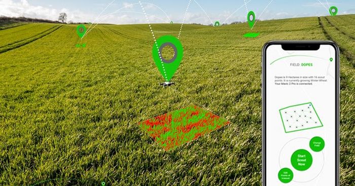
Crop scouting and EOSDA farming apps can make scouting more effortless and more accurate. In addition, most apps provide many additional features, including historical weather data, crop threat notifications, and zoning. Digital platforms and applications can take field scouting and monitoring to a new level of efficiency.
Farmer’s concerns may vary by region and farm size. However, most farmers are faced with soil problems, plant diseases, and pest attacks during the growth period. In addition, nutrient and fertilization decisions can also be challenging.
Crop scouting updated thanks to the development of technology. Nowadays, this sector gets more valuable opportunities. Using drones with cameras that map fields and scan crops quickly, you can get images without the expense and effort. It is a tremendous technical help for scouts, as they can immediately identify areas that need more detailed inspection without being in the field.
Satellite imagery is another revolutionary technology for agriculture. This technology is even more beneficial than drones, especially when it comes to large areas. For example, using satellite imagery, you can quickly get a map of a large area in a short time. These maps are regularly updated, and on them, you can see the changes that have occurred in the fields. Images are provided in high definition. In addition, satellite imagery makes it possible to see things that are not subject to human vision, since maps are compiled based on the wavelengths of light.
Remote sensing makes it possible to see what the human eye is unable to perceive. We can see red or purple, but there is also an infrared spectrum and ultraviolet radiation. We have limits, and remote sensing helps us see a complete picture of how light interacts with plants. For example, humans can identify a healthy plant by looking at green leaves because a pigment called chlorophyll absorbs all waves of light other than green that we can see. But we cannot see how it reflects light in the near-infrared range.
How Internet and GPS boost crop scouting? The Internet gives scouts an improved way of transferring data. For example, you want to share information about a problem area without the Internet. In that case, you can tell about it by phone, but having a network connection and a smartphone or tablet, you can transfer a full report directly from the field. It saves you tons of time and doesn’t miss anything. Thanks to GPS technology, the scout can also inform the employer about the problem area location by marking it on a map and saving the data. The Internet and GPS offer the precision that traditional communication means.
Crop Scouting and Drones & Satellite Imagery
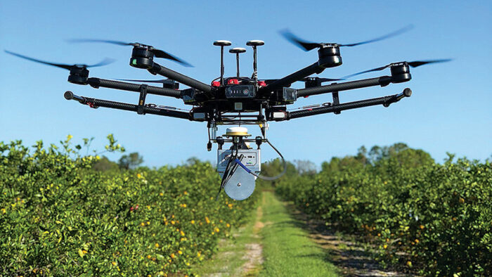
There are several ways to obtain aerial photographs. Farmers can use unmanned aerial vehicles or drones, manned aircraft, and satellite images. At the same time, the most popular today are drones and satellite images. Drones provide the best resolution images, as they are equipped with high-quality cameras and offer various image capture times. While drone battery life has improved significantly in recent years, it remains a significant limiting factor to consider.
Drones offer many valuable opportunities for agriculture. With their help, you can take pictures from a bird’s eye view and monitor the fields. In addition, drones are used to create 3D maps. The devices can also be used for planting seeds, fertilizing, and helping the irrigation system.
Satellite imagery has continued to improve for several decades. Timing and quality improvement remain a priority. Various platforms offer images with a resolution of up to one meter per pixel. However, weather conditions, including cloudiness, can still interfere with taking pictures. If the weather is cloudy for several days, you may not get images of your crops at a particular stage of development.
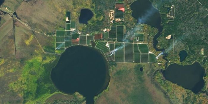
One of the main advantages of satellite imagery is the fact that it is archived, which means you have the opportunity to look into the past and assess the state of your fields. It is an effective solution for identifying patterns and characteristics of the farm. Due to the patterns and valuable data, farmers can create and develop more effective plans. It is also an excellent way to check if the farming practices and methods you chose work. In addition, it is possible to detect changes that have occurred under the influence of the environment and climate.


